



A framework for the next thirty years
To transform Tog Wajaale into a vibrant, sustainable, and inclusive city by providing affordable housing, expanding infrastructure, fostering economic growth, preserving cultural heritage, and promoting eco-friendly, climate-resilient urban development.
Vision statement
"To transform Tog Wajaale into a regional center for commerce, education and culture by 2055, with a diversified economy including manufacturing, services, and sustainable industries, while integrating principles of green urbanism, renewable energy, and climate resilience."
Specific objectives
- Accommodate population growth with affordable, inclusive housing and essential services like water, sanitation, healthcare, education, and electricity.
- Integrate sustainable practices such as green spaces, waste management, and energy efficiency for resilience against climate change.
- Stimulate economic development through job creation, industrial expansion, and cultural preservation.
- Develop efficient infrastructure and transportation networks to reduce congestion and promote eco-friendly mobility.
Strategic goals
| Goal | Description |
|---|---|
| Infrastructure Development | Build resilient, interconnected infrastructure to support urbanization and cross-border trade. |
| Economic Growth & Diversification | Position Tog Wajaale as a regional trade and innovation hub with Special Economic Zones and digital entrepreneurship. |
| Housing and Social Services | Ensure equitable access to quality housing and services through inclusionary zoning and community programs. |
| Environmental Sustainability | Integrate climate resilience with waste-to-energy plants and green certifications. |
| Social Inclusivity | Empower marginalized groups through participatory planning and inclusive governance. |
Legal and institutional framework
The plan is prepared in accordance with the Ethiopian Urban Planning Proclamation (No. 574/2008), Somali Regional State urban development regulations, and national urban development strategies. It supports Cities Alliance principles and results-based urban planning, and aligns with the Sustainable Development Goals, particularly SDG 11 (Sustainable Cities and Communities).
Project team
A dedicated multidisciplinary team spanning urban planning, engineering, environment, and community engagement leads the plan's implementation.

Shemshedin Hassen Yusuf

Mohammed Muhumed Ahmed

Mohammed Isse Muhumed

Abdiwasac Khaliif Muhumed

Ubax Siyad Sheikh

Mayor

Deputy Mayor

Abdikarim Hassen Yusuf
Team structure & responsibilities
The project team operates under the Tog Wajaale City Administration with support from the Somali Regional Urban Development Bureau, ensuring comprehensive coverage of every technical area required for implementation:
- Project Management: Overall coordination, stakeholder engagement, and reporting
- Technical Planning: Urban design, zoning regulations, and spatial planning
- Engineering: Infrastructure design, specifications, and construction supervision
- Environmental Compliance: Impact assessments, monitoring, and sustainability standards
- Survey & GIS: Spatial data management, mapping, and land administration
- Administration: Documentation, logistics, and operational support
Maps & visuals gallery
Planning documents and spatial visualizations guiding the urban expansion process. Click any image for a larger view.

Contour Analysis Map — Topographic elevation analysis

Digital Elevation Model (DEM) — 3D terrain visualization
_AND_EXPANSION_BOUNDARY.png)
Built-Up & Expansion Boundary — Urban growth limits

Existing & Expansion Road Network — Transportation infrastructure planning

Location Map — Regional context and positioning
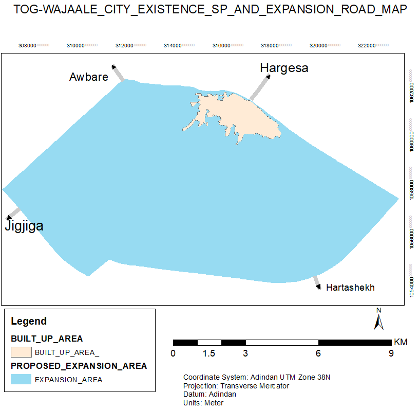
Detailed Road Network — Street hierarchy and connectivity

Current Road Network — Baseline transportation assessment

Integrated Road Network — Current and future road systems
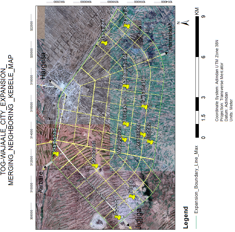
Kebele Integration Map — Administrative boundary adjustments

Expansion Road Network — Future transportation corridors

Implementation Phases — 30-year development timeline
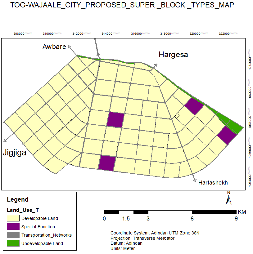
Super Block Typology — Land use and zoning patterns

Undevelopable Land Analysis — Environmental constraints assessment

Development Scenarios — Growth pattern alternatives
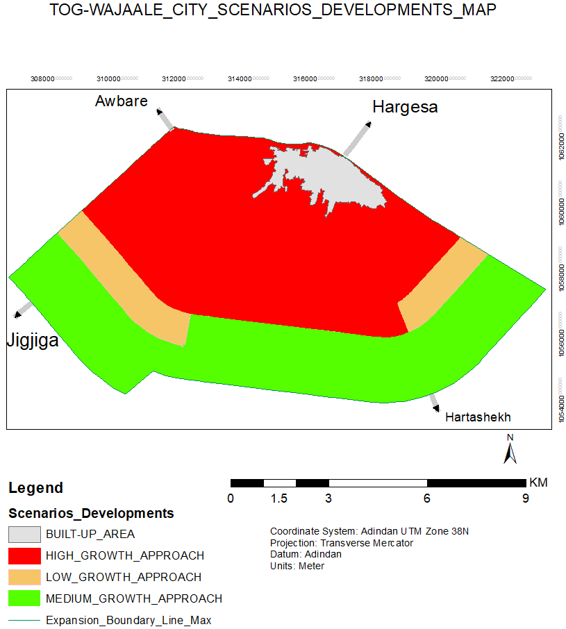
Scenario Analysis 2 — Comparative development options

Slope Analysis — Terrain gradient assessment
Map development process
All maps are developed using GIS technology with field verification:
- High-resolution satellite imagery acquisition and analysis
- Field surveys with GPS data collection and ground-truthing
- Topographic and hydrological analysis for drainage planning
- Community boundary verification and stakeholder consultation
- Technical validation by urban planning and engineering experts
- Multi-stakeholder review and final approval by city administration
Total mapping area: approximately 4,500 hectares covering existing urban area and expansion zones
Data sources: Ethiopian Geospatial Information Agency (EGIA), Sentinel-2 satellite imagery, field surveys (2024)
Project video gallery
Visual representations of future urban expansion in Tog Wajaale — road networks, scenario developments, and built-up area analyses.
Video series overview
This series provides visual documentation of Tog Wajaale's urban expansion planning process:
- Road Network Visualizations (1–4, 7): Detailed road infrastructure plans and connectivity
- Scenario Development Maps (5–6, 8–10): Different growth scenarios and future planning options
- Built-up Area Analysis: Existing strengths and proposed development areas
- Future Vision Planning: The comprehensive 30-year urban expansion strategy
Implementation phases
The expansion plan is structured into three ten-year phases, each with specific components and deliverables.
| Phase | Timeframe | Key components | Estimated investment |
|---|---|---|---|
| Phase 1: Foundation | 2025–2035 | Primary road network, drainage systems, water supply, land subdivision, basic community facilities | USD 85–100M |
| Phase 2: Consolidation | 2035–2045 | Secondary infrastructure, housing development, commercial areas, public spaces, institutional facilities | USD 120–140M |
| Phase 3: Maturation | 2045–2055 | Green network completion, urban amenities, technology integration, tourism development, full urbanization | USD 90–110M |
Short-term (2025–2030): Growth and infrastructure development
- Population and Land Use Assessment: Establish foundational understanding of growth trends.
- Infrastructure Expansion: Expand roads, utilities, and public services.
- Urban Growth Management: Ensure sustainable early-stage growth.
Mid-term (2031–2045): Expansion and economic development
- Growth Management and Zoning: Optimize zoning for rapid growth.
- Infrastructure Scaling: Major projects to support over 300,000 residents.
- Sprawl Prevention: Promote sustainable patterns and conservation.
Long-term (2046–2055): Development and sustainability
- Comprehensive Planning: Plan for 554,700 residents with mixed-use areas.
- Infrastructure Overhaul: Advanced systems including wastewater recycling.
- Environmental Sustainability: Green building standards and urban forestry.
Interactive plan map
Explore zoning and strategic projects below. Use the layer control () in the top-right to toggle planning layers, and click any zone or marker for details.
Explore in Google Earth
View the full proposed land use plan and urban expansion boundaries in an interactive 3D visualization.
Open in Google EarthIncludes detailed proposed land use zones, expansion corridors, and strategic development areas for 2025–2055.
Map legend
Phase 1 (2025–2035) Phase 2 (2035–2045) Phase 3 (2045–2055)
Key project locations
Data source: Tog Wajaale Municipal GIS Unit · Last updated April 2024
Development scenarios
The plan considers low, medium, and high growth scenarios to prepare for different futures:
- Low Growth: Focus on basic infrastructure and controlled expansion.
- Medium Growth: Balanced development with emphasis on sustainability.
- High Growth: Aggressive economic and infrastructure scaling.
Progress reports
As of Q1 2026, the plan has completed its technical preparation phase and entered early implementation. Below is the official progress report submitted to regional authorities.
Dear Mr. Yusuf,
In line with the agreed reporting and coordination arrangements for the Tog-Wajaale Urban Expansion Plan (UEP), and in support of transparency and results-based implementation, we are pleased to submit the Monthly Construction Progress Report for January 2026 for your review and information.
This submission, issued as Report No. 01, provides an overview of physical progress, financial execution, and implementation performance of the Road Infrastructure Development component being undertaken through the Force Account modality. The report covers the period from the commencement of activities in December 2025 through 31 January 2026.
Key highlights of the reporting period include:
- Physical Progress: Site clearing and grubbing works have reached approximately 80% completion, covering 4.76 km of the planned 5.95 km corridor, exceeding the scheduled target for the reporting period.
- Financial Performance: Works amounting to ETB 640,000 (80% of the approved contract value) have been certified, with ETB 400,000 disbursed to date against a total budget allocation of ETB 800,000 for the fiscal year.
- Implementation Status: Overall project performance is assessed as Good, with no major technical, operational, or resource-related constraints identified. Progress was jointly reviewed and verified during a site inspection conducted on 04 January 2026 by representatives of the City Administration and relevant regional institutions.
- Next Steps: The forthcoming period will focus on completing the remaining 1.19 km of earthworks and initiating preparatory activities for the next phase, including pavement construction and utility installation, planned for the subsequent fiscal year.
The report has been prepared and validated by the UEP Project Team and reflects steady progress toward the planned objectives. We are encouraged by the positive implementation trajectory and remain committed to maintaining momentum in line with agreed work plans and development partner expectations.
We appreciate the continued collaboration and support of all stakeholders toward the successful implementation of the Urban Expansion Plan.
Yours sincerely,
Urban Expansion Plan Directorate
Tog-Wajaale City Administration
Investment & partnership opportunities
Tog Wajaale's strategic expansion presents high-impact opportunities aligned with national growth and regional integration goals. We invite collaboration with international donors, private investors, and development partners.
Core infrastructure & public-private partnerships
- Primary Road Network & Utilities: Co-financing and construction contracts for Phase 1 arterial roads (12.3 km), drainage systems, and water distribution networks. Estimated value: USD 35–45M
- Wastewater Treatment Plant: Build-Operate-Transfer (BOT) opportunity for a modern facility serving 50,000+ residents. Estimated value: USD 15–20M
- Solid Waste Management: Investment in recycling facilities and a waste-to-energy conversion plant. Estimated value: USD 8–12M
Housing & real estate development
- Mixed-Income Housing Projects: 2,500+ planned serviced plots for large-scale residential development. Land available: 85 hectares
- Commercial Corridors Development: Prime land for shopping complexes, hotels, and office spaces along new primary roads. 120+ plots available
Special Economic Zone & logistics
- Light Manufacturing & Agro-Processing: Incentivized plots within a designated 40-hectare SEZ near the border crossing. Tax holidays: 5–7 years
- Dry Port & Logistics Hub: Joint venture for a modern logistics center with customs facilities, warehousing, and truck parking. Estimated value: USD 25–35M
Climate & community resilience projects
- Urban Green Spaces & Parks: Grant funding and technical partnership for "Green Network" implementation (45 hectares).
- Solar Energy Micro-Grids: Pilot projects for renewable energy in public infrastructure and residential areas.
- Community Facility Co-Funding: Schools, health clinics, vocational training centers, and markets open for donor naming. 10+ facilities planned
Next steps for potential partners
- Review Detailed Documentation: Access pre-feasibility studies, design reports, and market analyses.
- Schedule Briefing: Contact the Project Management Unit for one-on-one or group briefings.
- Submit Expression of Interest (EOI): Formal EOIs should outline the sector of interest and proposed partnership model.
Investment incentives
Qualifying projects may be eligible for:
- Income tax holidays (3–7 years depending on sector and investment size)
- Duty-free import of capital goods and construction materials
- Long-term land lease arrangements (up to 50 years with renewal option)
- Fast-tracked permit processing through one-stop service
All projects align with Ethiopian investment laws (Proclamation No. 1180/2020) and may qualify for applicable national and regional incentives.
Municipal staff systems
Digital attendance management for Tog-Wajaale City Municipality employees — check in, request leave, and track hours from any device.
For technical support: axmed@togwajaale.gov.et · HR: ubax@togwajaale.gov.et
Contact & further information
For inquiries, partnership discussions, or detailed information about the plan, contact the relevant offices below.
Project Management Unit
Address: Tog Wajaale Municipality Building, Main Street, Tog Wajaale, Somali Region, Ethiopia
Email: twuep.pmu@somaliregion.gov.et
Office hours: 8:30 AM–5:30 PM (EAT), Sunday–Thursday
Project leadership
Director, TWUEP: Mr. Shemshedin Hassen Yusuf — +251 911 542418
City Manager: Mr. Abdikarim Hassen Yusuf — +251 915 074535
Quick attendance stats
Key contacts
Mayor: +251 915 330528
Deputy Mayor: +251 915 456 066
General inquiries: info@togwajaaleurbanplan.et
Tog-Wajaale City Administration, Somali Regional State, Ethiopia